
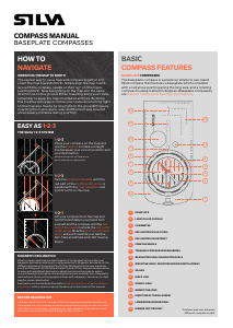
COMPASS MANUAL
BASEPLATE COMPASSES
8
GRADUATION RING / GRADUATION SCALE
The angle between true North and the direction of travel is called bearing (the direc-
tion from where you are, to where you want to go). The value of this angle can be read
directly o the scale on the graduation ring. Our compasses have either a graduation
scale divided into 360 degrees or 6400 mils. The Graduation ring is also marked with
the cardinal points (N-S-E-W) on some models.
If you rotate the graduation ring to line-up the red north of the compass needle to the
North arrow, a bearing can be taken from the graduation scale at the index line.
9
ORIENTING LINES / ORIENTING ARROW (NORTH ARROW)
All our outdoor compasses have red/black north-south lines and arrow in the capsule
bottom ensure easy and safe settling. The lines and arrow are fixed within the com-
pass housing, aligned to north on the graduation ring and designed to be aligned with
the map meridians. Half the lines/arrow are coloured red to indicate north. The lines
are used to align the compass housing with the map in step 2, when navigating with
the SILVA 1-2-3 system.
10
SCALES
On the baseplate you’ll find scales for measuring distances etc. on a map. The type
and number of scales varies between each SILVA compass model. The scales and
prints on most SILVA compasses are “hot stamped” to ensure extra durability.
MAP MEASURING SCALES
A map is a reduced picture of the terrain. The determined proportion between the
distances on the map and the corresponding distance on the ground is called a map
scale. To obtain the corresponding distance in the field, the distance on the map
must be multiplied by the divider of the scale. The most common scales are 1:10 000,
1:15 000, 1:25 000 and 1:50 000. For example, the scale 1:10 000 means that 1 cm on
the map corresponds to 10 000 cm = 100m in the terrain.
RULER
If the map scale is 1:50 000, and your compass has the corresponding map measuring
scale, use this to measure distance.
If your compass lacks the corresponding map measuring scale, use the regular Metric
or Imperial Ruler found on the edge of the baseplate.
Example: If the map scale is 1:50 000, then 1 mm on the map = 50m in the terrain.
Example: If the map scale is 1:24 000, then 1 inch on the map = 24000 inches (2,000
feet) in the terrain.
ROMER SCALES
Use the Romer coordinate scales on the baseplate
to measure distance or accurately work out a six-
figure grid reference that lets you determine the
coordinates of a known position on the map (or to
determine the position of known coordinates on
the map).
11
INDEX LINE
The index line is fixed beneath, or at the outer edge of the graduation scale as an
extension of the direction of travel arrow. It marks the bearing you set by rotating the
compass housing.
If you rotate the graduation ring to line-up the red north of the compass needle to the
North arrow, a bearing can be taken from the graduation scale at the index line.
12
STENCIL HOLE
The baseplate has one or several stencil holes for adding map symbols/marking posi-
tions on map with pen/pencil – increasing precision.
13
MAGNIFYING LENS
Built in magnifier for detailed map reading.
14
DIRECTION OF TRAVEL ARROW
The direction of travel arrow shows the direction that you want to travel along or the
bearing you are taking. It is fixed parallel to the sides of the baseplate and aligned
with the fixed index line on the edge of the compass housing.
15
LUMINOUS MARKINGS/RING
Our compasses have luminous markings and/or graduation
ring for compass reading in the dark. Once activated by
daylight/flashlight they will give light up to 4 hours of light.
The markings are commonly placed at the direction of travel
arrow, the North arrow, the index line and north part+pivot of
the compass needle.
16
RUBBER FRICTION FEET
Silicon rubber friction feet for precision map work. Placed at the bottom side of the
baseplate.
BASEPLATE COMPASSES
BASIC
COMPASS FEATURES
1
BASEPLATE
Highly durable baseplate in transparent acrylic plastic. Use the edge of the baseplate
to get your bearing. Most SILVA compasses has a curved up back end to make it sit
more ergonomic in your hand.
2
LIQUID FILLED CAPSULE
The capsule is filled with anti-static liquid (customized formula) that ensures clear
reading, fast settling time, perfect dampening, stability and accuracy of the needle.
3
CLINOMETER
The clinometer can be used for measuring slopes of terrain, heights, etc.
Rotate the Graduation ring until “W’ (270°) is at the Index line. Hold compass at eye
level, on its side. The clinometer needle should move freely. Tilt the compass upward,
with the terrain. Read inclination from where the inclination needle meets the declina-
tion scale.
4
5
DECLINATION SCALE (FIXED) / DECLINATION ADJUSTMENT
ABOUT DECLINATION
When compass and map are used together it’s important to know the
local magnetic declination and how to compensate for it.
Magnetic declination is the dierence between Geographic North/True
North (where the map meridians point) and Magnetic North (where the
North end of the compass needle points). In areas with significant dec-
lination, adjustments must be made to walk a correct bearing. Informa-
tion concerning the amount and direction of magnetic declination is
shown on topographical maps with a diagram, identifying Magnetic
North (MN) and the degree variance from True North (TN). Use an up to
date map for current declination.
FIXED SCALE
Most SILVA compasses have a fixed declination correction scale inside the capsule to
simplify the calculations required.
How to:
Identify the declination variance from your map.
In this example, 20° east.
Follow the instructions in the SILVA 1-2-3 system. Before
taking a landmark in step 3, turn yourself until the red end
of the compass needle points to 20° on the “E.decl.” scale.
Keep the compass steady and turn the compass housing
until the North arrow coincides with the red end of the compass needle once again.
Now the direction of travel arrow will point towards your destination. Take a landmark
and start moving.
ADJUSTMENT SCREW
Some SILVA compasses have a declination adjustment screw, located on the bezel.
A small screwdriver can be found inside the safety
release of the included lanyard.
How to:
Identify the declination variance from your map.
In this example, 20° east.
Turn the screw on the bezel until the bottom side of the
North Arrow meets the 20° at the “E.decl” scale.
Remember to use the orienting lines at the bottom of
the capsule and NOT the North Arrow as map North
reference lines when taking the bearing on the map. After
you have adjusted your compass for declination, the
compass needle still points towards magnetic north.
6
COMPASS NEEDLE
Swedish high quality, stainless steel, magnetic needle. The combination of a sapphire
jewel bearing and a hardened steel pivot minimises friction, which in turn gives rapid
and accurate movements. Magnetic North direction accuracy: 1 degree.
The red end points to magnetic north!
7
TURNABLE COMPASS HOUSING (BEZEL)
Use the turnable compass housing to set your bearing or when navigating with the
SILVA 1-2-3 system. Some of our compasses are equipped with a rubber, tactile grip
ring to make the housing easier to adjust.
20˚
20˚
E. decl.
on map


Praat mee over dit product
Laat hier weten wat jij vindt van de Silva Ranger Global Kompas. Als je een vraag hebt, lees dan eerst zorgvuldig de handleiding door. Een handleiding aanvragen kan via ons contactformulier.